Published: August 23, 2026
Updated: August 23, 2026
Category: Odisha Weather News / Odisha Flood News / Breaking News
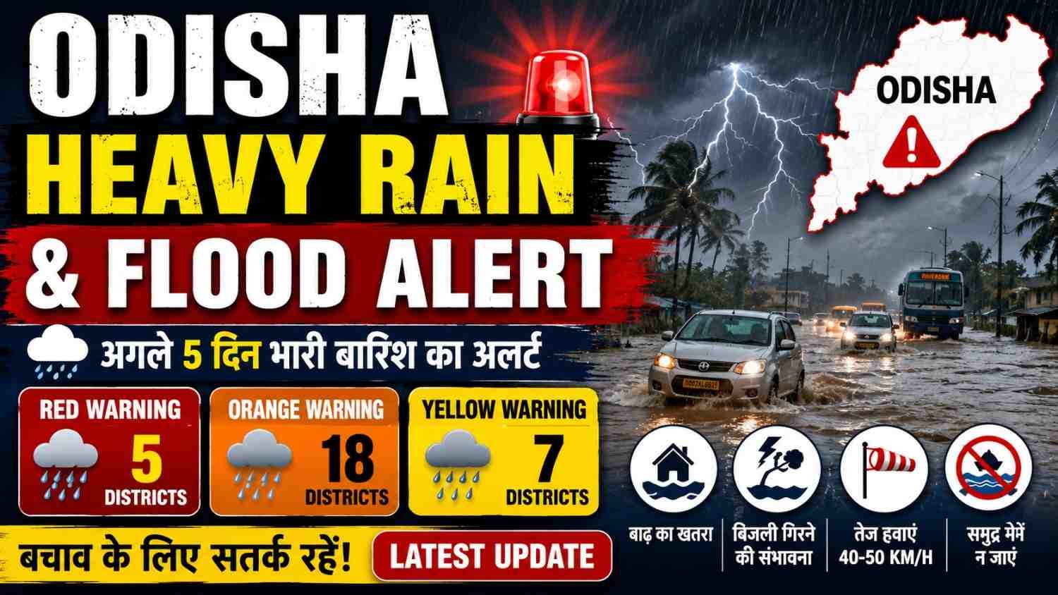
The Odisha Heavy Rain & Flood Alert has become a major concern as the India Meteorological Department (IMD) has warned of heavy to very heavy rainfall across several parts of Odisha, with extremely heavy rainfall possible at isolated places.
According to the latest IMD Bhubaneswar evening bulletin issued at 7:00 PM on August 23, 2026, a low-pressure area is currently positioned over the northwest Bay of Bengal and adjoining Gangetic West Bengal and North Odisha. The associated cyclonic circulation extends up to about 7.6 km above mean sea level and the system is expected to move nearly northwestwards across North Odisha and adjoining Gangetic West Bengal during the next 24 hours.
The latest warning has raised concerns about additional waterlogging, localised flooding and rising river levels in already affected areas of the state.
Odisha Heavy Rain & Flood Alert: Latest Weather Update Today
The latest Odisha Heavy Rain & Flood Alert indicates that rainfall activity will remain active across the state.
IMD has forecast light to moderate rain or thundershowers at most places across Odisha during the next 24 hours. Heavy to very heavy rainfall is expected at a few places in several districts, while isolated extremely heavy rainfall is also possible.
The current weather system over the northwest Bay of Bengal is one of the main factors behind the enhanced rainfall activity.
Odisha Heavy Rain & Flood Alert: IMD Red Warning Districts
Under the latest Odisha Heavy Rain & Flood Alert, IMD has issued a Red Warning for the following districts for the period ending at 8:30 AM on August 24:
- Cuttack
- Angul
- Dhenkanal
- Kalahandi
- Nabarangpur
IMD forecasts heavy to very heavy rainfall at a few places in these districts, with extremely heavy rainfall possible at one or two places.
Residents in these districts should closely follow official weather and disaster-management advisories.
Odisha Heavy Rain & Flood Alert: Orange Warning Districts
The current Odisha Heavy Rain & Flood Alert also includes an Orange Warning for a large number of districts.
The districts under the Orange Warning for heavy to very heavy rainfall include:
- Balasore
- Bhadrak
- Jajpur
- Kendrapara
- Jagatsinghpur
- Sambalpur
- Deogarh
- Keonjhar
- Mayurbhanj
- Subarnapur
- Boudh
- Kandhamal
- Rayagada
- Koraput
- Malkangiri
- Puri
- Khordha
- Nayagarh
The warning is valid for the current 24-hour forecast period ending at 8:30 AM on August 24, according to IMD Bhubaneswar.
Odisha Heavy Rain & Flood Alert: Yellow Warning Districts
The Odisha Heavy Rain & Flood Alert also places several districts under a Yellow Warning for heavy rainfall.
These include:
- Sundargarh
- Jharsuguda
- Bargarh
- Nuapada
- Balangir
- Gajapati
- Ganjam
Thunderstorms, lightning and gusty winds are also possible in these areas.
Odisha Heavy Rain & Flood Alert: August 24 Weather Forecast
The Odisha Heavy Rain & Flood Alert remains important on August 24 because rainfall is expected to continue across the state.
For August 24, IMD forecasts light to moderate rain or thundershowers at most places over Odisha. Heavy to very heavy rainfall is expected at one or two places in Sundargarh, Jharsuguda, Bargarh, Sambalpur, Subarnapur and Boudh, which are under an Orange Warning.
Several other districts are under a Yellow Warning for heavy rainfall.
Odisha Heavy Rain & Flood Alert: August 25 Weather Forecast
The Odisha Heavy Rain & Flood Alert continues into August 25.
IMD expects light to moderate rain or thundershowers at most places across Odisha. An Orange Warning has been issued for Sundargarh, where heavy to very heavy rainfall is possible at one or two places.
A Yellow Warning for heavy rainfall has also been issued for Jharsuguda, Bargarh, Sambalpur, Deogarh, Keonjhar and Balangir.
Odisha Heavy Rain & Flood Alert: August 26 Weather Forecast
The Odisha Heavy Rain & Flood Alert remains active on August 26.
IMD forecasts light to moderate rain or thundershowers at many places across Odisha. Sundargarh remains under an Orange Warning for heavy to very heavy rainfall.
Jharsuguda, Bargarh, Sambalpur, Deogarh, Keonjhar and Mayurbhanj are under a Yellow Warning for heavy rainfall.
Odisha Heavy Rain & Flood Alert: August 27 to August 29 Forecast
The Odisha Heavy Rain & Flood Alert is expected to continue beyond August 26, although the warning intensity varies by district.
For August 27, heavy rainfall is possible at one or two places in Sundargarh, Keonjhar and Mayurbhanj.
For August 28, heavy rainfall is forecast in Balasore, Jajpur, Sundargarh, Deogarh, Angul, Dhenkanal, Keonjhar and Mayurbhanj.
For August 29, heavy rainfall is possible in Sundargarh, Jharsuguda, Sambalpur, Deogarh, Angul, Keonjhar and Mayurbhanj.
Odisha Heavy Rain & Flood Alert: Why Is Odisha Receiving Heavy Rain?
The Odisha Heavy Rain & Flood Alert is linked to a low-pressure area over the northwest Bay of Bengal and surrounding regions.
According to IMD, the low-pressure area was located over the northwest Bay of Bengal and adjoining Gangetic West Bengal and North Odisha at 2:30 PM on August 23. Its associated cyclonic circulation extends vertically to around 7.6 km above mean sea level.
The system is expected to move nearly northwestwards across North Odisha and adjoining Gangetic West Bengal during the next 24 hours.
Odisha Heavy Rain & Flood Alert: Flood Situation in North Odisha
The Odisha Heavy Rain & Flood Alert comes at a time when several parts of the state are still dealing with the effects of earlier flooding.
Recent reports from Akashvani News said the flood situation in northern Odisha had affected several districts, with rivers including the Baitarani, Brahmani and Salandi flowing above danger levels during the earlier phase of the flooding.
Because some areas remain waterlogged or vulnerable, additional rainfall can increase the risk of localised flooding and riverine flooding.
Odisha Heavy Rain & Flood Alert: How Many People Have Been Affected?
The Odisha Heavy Rain & Flood Alert follows a significant flood situation in the state.
Akashvani News reported on August 22 that approximately 14 lakh people had been affected across several districts, while many areas remained inundated. The same report said that the state government had undertaken evacuation and relief measures as the flood situation evolved.
These figures relate to the earlier flood situation and should not be interpreted as a new August 23 casualty or affected-population figure unless officially updated.
Odisha Heavy Rain & Flood Alert: Which Rivers Are Being Watched?
The Odisha Heavy Rain & Flood Alert makes river levels an important issue, particularly in northern Odisha.
During the recent flood situation, the Baitarani, Brahmani and Salandi rivers were reported to be flowing above danger levels in affected areas.
With additional rainfall forecast, residents living near rivers, streams, low-lying areas and flood-prone zones should remain alert to official warnings.
Odisha Heavy Rain & Flood Alert: Risk of Local Flooding and Waterlogging
The Odisha Heavy Rain & Flood Alert also raises concerns about urban waterlogging and localised flooding.
IMD’s latest impact assessment warns of:
- Localised flooding of roads
- Waterlogging in low-lying areas
- Possible closure of underpasses
- Reduced visibility during heavy rainfall
- Traffic disruption
- Minor damage to vulnerable roads
- Possible damage to vulnerable structures
- Landslides or mudslides in susceptible areas
- Damage to standing crops
- Possible riverine flooding in some river catchments
Residents should check traffic conditions before travelling during periods of intense rainfall.
Odisha Heavy Rain & Flood Alert: Thunderstorm and Lightning Warning
The Odisha Heavy Rain & Flood Alert is not limited to rainfall.
IMD has also warned of thunderstorms, lightning and gusty surface winds in several districts. Wind speeds could reach 40–50 kmph in some areas during the warning period.
People are advised to remain indoors during thunderstorms and avoid standing under isolated trees.
Odisha Heavy Rain & Flood Alert: Safety Guidelines for Residents
During the Odisha Heavy Rain & Flood Alert, residents should follow these basic safety precautions:
- Stay updated through official IMD and district administration alerts.
- Avoid unnecessary travel during extremely heavy rainfall.
- Do not enter flooded roads or flowing water.
- Never attempt to cross a swollen river or stream.
- Keep away from electrical poles and fallen power lines.
- Do not shelter under trees during lightning.
- Stay inside a safe building during thunderstorms.
- Keep important documents and essential medicines in waterproof packaging.
- Keep mobile phones charged during severe weather.
- Follow evacuation instructions immediately if issued by authorities.
IMD specifically advises people to stay indoors, close doors and windows, avoid travel where possible, avoid taking shelter under trees and move to safer places if conditions worsen.
Odisha Heavy Rain & Flood Alert: Advice for People in Flood-Prone Areas
The Odisha Heavy Rain & Flood Alert is particularly important for people living in low-lying and flood-prone areas.
Residents should monitor:
- River water levels
- Local administration announcements
- Road closure information
- Evacuation announcements
- Rainfall warnings
- Lightning alerts
- Power supply warnings
- School and transport advisories
If authorities order evacuation, residents should leave early rather than waiting for floodwater to rise further.
Odisha Heavy Rain & Flood Alert: Fishermen Warning
The Odisha Heavy Rain & Flood Alert also includes a marine warning.
IMD has warned of squally weather with winds of 40–50 kmph occasionally gusting to 60 kmph along and off the Odisha coast through August 24.
Sea conditions are expected to remain rough to very rough, and fishermen have been advised not to venture into the sea along and off the Odisha coast until August 24.
Odisha Heavy Rain & Flood Alert: What Should Travellers Do?
The Odisha Heavy Rain & Flood Alert may affect road travel, particularly in areas experiencing intense rainfall.
Heavy rain can reduce visibility and cause waterlogging. IMD advises travellers to check traffic conditions before starting their journey and follow traffic advisories issued by authorities.
People travelling through flood-prone roads should avoid taking unnecessary risks and use alternative routes when authorities advise against travel.
Odisha Heavy Rain & Flood Alert: What Does Red, Orange and Yellow Warning Mean?
The Odisha Heavy Rain & Flood Alert uses different warning colours to communicate the level of weather risk.
Red Warning: Take action. Severe weather is expected and people should follow official safety instructions.
Orange Warning: Be prepared to take action. Significant weather conditions are possible and residents should remain prepared.
Yellow Warning: Be aware. People should stay informed and monitor changing weather conditions.
These warnings can change as new observations and forecasts become available.
Odisha Heavy Rain & Flood Alert: Latest 7-Day Warning Summary
The latest Odisha Heavy Rain & Flood Alert from IMD gives the following broad warning outlook:
- August 23: Extremely heavy rain warning
- August 24: Very heavy rain warning
- August 25: Very heavy rain warning
- August 26: Very heavy rain warning
- August 27: Heavy rain warning
- August 28: Heavy rain warning
- August 29: Heavy rain warning
The exact warning category varies by district, so readers should check the district-specific IMD forecast before making travel or outdoor plans.
Odisha Heavy Rain & Flood Alert: Will Schools and Colleges Be Closed?
The Odisha Heavy Rain & Flood Alert does not automatically mean that all schools and colleges across Odisha will be closed.
School or college closures are normally announced by the relevant state, district or local authorities depending on conditions.
Therefore, parents and students should rely on official notices from their district administration, school/college authorities and the Odisha government rather than social-media messages.
Odisha Heavy Rain & Flood Alert: Will There Be More Flooding?
The Odisha Heavy Rain & Flood Alert indicates an increased risk of localised flooding, waterlogging and riverine flooding in susceptible areas.
However, it is not accurate to state that every district will experience flooding.
The actual flood impact will depend on rainfall intensity, river levels, drainage conditions, reservoir releases, soil saturation and local geography.
IMD itself lists the possibility of riverine flooding in some river catchments among the potential impacts of heavy rainfall.
Odisha Heavy Rain & Flood Alert: Odisha Weather Forecast for Bhubaneswar
The Odisha Heavy Rain & Flood Alert also affects the Bhubaneswar area.
IMD’s local forecast for Bhubaneswar indicates generally cloudy conditions with one or two spells of rain or thundershower during the next 24 hours. The forecast maximum and minimum temperatures are around 31°C and 26°C, respectively.
People in the capital should remain alert to sudden heavy showers, lightning and temporary waterlogging.
Odisha Heavy Rain & Flood Alert: Important Official Weather Sources
The Odisha Heavy Rain & Flood Alert can change quickly, so readers should check official sources for the latest information.
Important sources include:
- India Meteorological Department
- Meteorological Centre, Bhubaneswar
- Odisha government departments
- District administrations
- Odisha State Disaster Management authorities
- Central Water Commission for river and flood information
IMD also recommends using the MAUSAM app for location-specific weather forecasts and warnings and the DAMINI app for lightning warnings.
Odisha Heavy Rain & Flood Alert: Latest Update and Conclusion
The latest Odisha Heavy Rain & Flood Alert shows that Odisha remains under a significant weather threat as a low-pressure area over the northwest Bay of Bengal is expected to move northwestwards across North Odisha and adjoining Gangetic West Bengal.
IMD has issued a Red Warning for Cuttack, Angul, Dhenkanal, Kalahandi and Nabarangpur for the next 24-hour period, while numerous other districts are under Orange or Yellow warnings.
The renewed rainfall comes while parts of Odisha are still recovering from flooding. Additional rain could result in waterlogging, local flooding, traffic disruption and rising river levels in vulnerable areas.
Residents are advised to monitor official weather updates, avoid unnecessary travel during intense rainfall, stay away from floodwater and follow instructions from local authorities.
This is a developing weather situation. Warning categories and district-specific forecasts can change with subsequent IMD bulletins. Always check the latest official advisory before making safety or travel decisions.
Odisha Heavy Rain & Flood Alert: Frequently Asked Questions
Odisha Heavy Rain & Flood Alert: Is Odisha under a rain warning today?
Yes. IMD has issued multiple weather warnings for Odisha, including a Red Warning for five districts and Orange and Yellow warnings for other districts.
Odisha Heavy Rain & Flood Alert: Which districts have a Red Warning?
Cuttack, Angul, Dhenkanal, Kalahandi and Nabarangpur are under the Red Warning for the current 24-hour period ending August 24 morning.
Odisha Heavy Rain & Flood Alert: Which districts have an Orange Warning?
The current Orange Warning covers several districts including Balasore, Bhadrak, Jajpur, Kendrapara, Jagatsinghpur, Sambalpur, Deogarh, Keonjhar, Mayurbhanj, Subarnapur, Boudh, Kandhamal, Rayagada, Koraput, Malkangiri, Puri, Khordha and Nayagarh.
Odisha Heavy Rain & Flood Alert: Is there a flood risk?
Yes, localised flooding, waterlogging and possible riverine flooding are among the impacts identified by IMD for heavy rainfall.
Odisha Heavy Rain & Flood Alert: Is the Bay of Bengal weather system responsible?
The current low-pressure area over the northwest Bay of Bengal and adjoining regions is contributing to the current weather conditions over Odisha.
Odisha Heavy Rain & Flood Alert: Should fishermen go to sea?
No. IMD has advised fishermen not to venture into the sea along and off the Odisha coast until August 24 because of rough to very rough sea conditions and strong winds.
Odisha Heavy Rain & Flood Alert: Where can I check the latest warning?
The latest district-wise warning should be checked through the India Meteorological Department and Meteorological Centre Bhubaneswar.
Odisha Heavy Rain & Flood Alert: SEO Title
Odisha Heavy Rain & Flood Alert: IMD Red Warning, Flood Risk & District-Wise Rain Forecast
Odisha Heavy Rain & Flood Alert: Meta Description
Odisha Heavy Rain & Flood Alert today: IMD issues Red, Orange and Yellow warnings. Check district-wise rain forecast, flood risk, safety tips and latest Odisha weather updates.
Odisha Heavy Rain & Flood Alert: Focus Keyword
Odisha Heavy Rain & Flood Alert
Odisha Heavy Rain & Flood Alert: SEO Keywords
- Odisha Heavy Rain & Flood Alert
- Odisha Heavy Rain Alert Today
- Odisha Flood Alert Today
- Odisha Weather Today
- Odisha Rain Alert Today
- Odisha IMD Weather Alert
- Odisha Red Alert Today
- Odisha Orange Alert Today
- Odisha Heavy Rainfall
- Odisha Flood News Today
- Odisha Weather Forecast
- Odisha District Wise Rain Alert
- Odisha Flood Warning
- IMD Odisha Alert
- Bhubaneswar Weather Today
- Odisha Monsoon Update
- Odisha Rain News
- Odisha Flood Update
- Odisha Weather News Today
- Odisha Latest Weather Update
Odisha Heavy Rain & Flood Alert: Suggested URL Slug
odisha-heavy-rain-flood-alert-today
Odisha Heavy Rain & Flood Alert: Suggested Image Alt Text
Odisha Heavy Rain & Flood Alert latest weather and flood warning in Odisha
Odisha Heavy Rain & Flood Alert: Suggested YouTube Title
Odisha Heavy Rain & Flood Alert Today | IMD Red Alert | Heavy Rain & Flood Warning | Odisha Weather
Odisha Heavy Rain & Flood Alert: Suggested YouTube Description
Odisha Heavy Rain & Flood Alert latest update: IMD has issued Red, Orange and Yellow weather warnings across Odisha amid an active low-pressure area over the northwest Bay of Bengal. In this video, check the latest district-wise rainfall warning, flood risk, river situation, safety precautions and Odisha weather forecast.
Stay updated with official IMD and Odisha government advisories before travelling or making outdoor plans.
Odisha Heavy Rain & Flood Alert: Editorial and AdSense-Friendly Disclaimer
This article is intended for general news and weather-information purposes. Weather forecasts and warnings can change rapidly. The information presented here is based on official weather bulletins and publicly available reports available at the time of publication.
For safety-critical decisions, readers should always follow the latest instructions issued by the India Meteorological Department, Odisha government, district administration and disaster-management authorities.
Last updated: August 23, 2026